
If a shipowner, a student or the head of a maritime academy looks up what radio equipment a ship needs, sooner or later they come across four labels: A1, A2, A3 and A4. These are the sea areas of the GMDSS (Global Maritime Distress and Safety System), and they determine which radio installation a ship subject to SOLAS must carry.
The information tends to be scattered across long regulatory PDFs and, in addition, much of what circulates is out of date: SOLAS chapter IV changed on 1 January 2024. This article summarizes what each area means and what is required in each, according to the text currently in force.
What sea areas A1 to A4 are
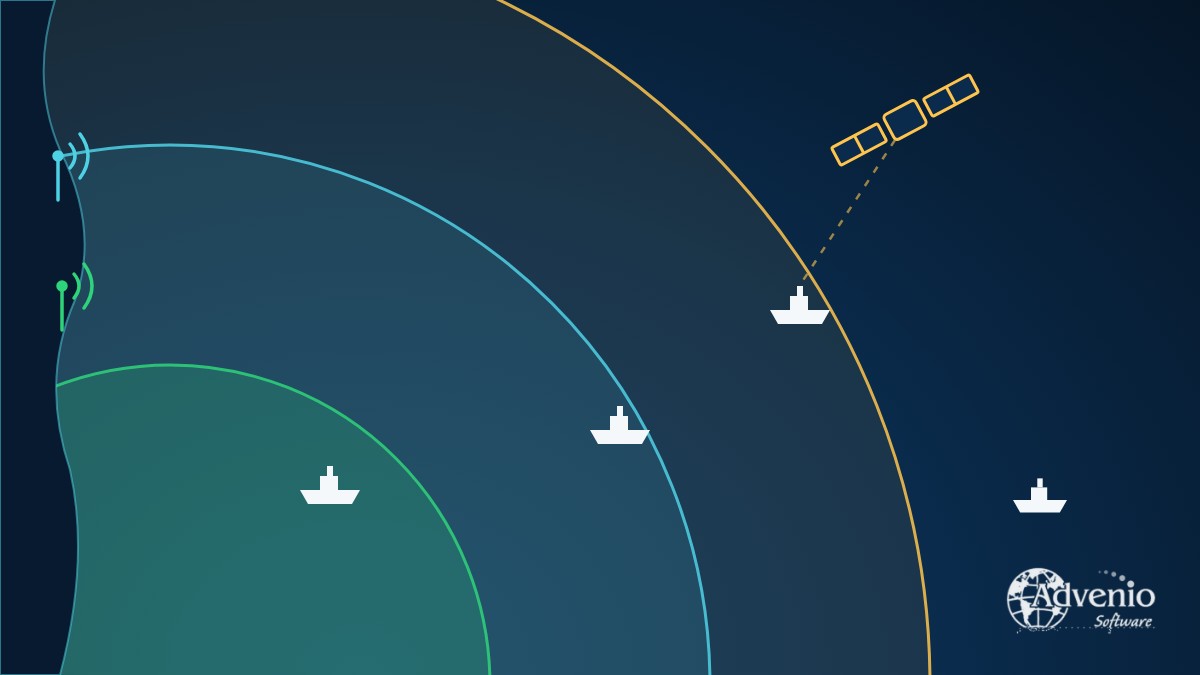
The first thing to be clear about is that they are not fixed zones drawn on a map of the world. They are defined by the type of radio coverage with continuous digital selective calling (DSC) alerting that exists in each place:
- A1: an area within the radiotelephone coverage of at least one VHF coast station, in which continuous DSC alerting is available.
- A2: an area, excluding sea area A1, within the radiotelephone coverage of at least one MF coast station, in which continuous DSC alerting is available.
- A3: an area, excluding sea areas A1 and A2, within the coverage of a recognized mobile satellite service, in which continuous alerting is available, supported by the ship earth station that the ship carries on board.
- A4: the rest: the area outside sea areas A1, A2 and A3.
Two practical consequences. The first: sea areas A1 and A2 are declared by each government according to the actual coverage of its coast stations. There is no single distance; as an order of magnitude, A1 is usually a few tens of miles around the coast and A2 extends considerably further, but it depends on the antenna and on each station. To find out whether a stretch of water is A1 or A2, you need to check what the country’s administration has declared.
The second: since 2024, A3 depends on the satellite equipment the ship carries. It is no longer “the Inmarsat coverage area”: it is the coverage of the recognized mobile satellite service that the ship has installed.
What all ships carry
Before considering the sea area, there is a set of equipment that chapter IV (regulation 7) requires of all ships to which it applies, whatever the area in which they sail:
- A VHF installation with DSC on channel 70 and radiotelephony on channels 6, 13 and 16, with a continuous DSC watch on channel 70.
- A radar SART or an AIS-SART, stowed so that it can be readily used.
- One or more receivers capable of receiving maritime safety information (MSI) and search and rescue information throughout the voyage.
- A 406 MHz EPIRB, installed in an easily accessible position, with a hydrostatic release (float-free), which activates automatically when it floats free and can also be activated manually.
- A VHF installation for general radiocommunications in the 156 to 174 MHz band.
What is added in each sea area
| Sea area | In addition to the above |
|---|---|
| A1 | A means of initiating ship-to-shore distress alerting from the navigating position. The text allows several alternatives, including the 406 MHz EPIRB installed close to that position (without losing the float-free release), MF or HF with DSC, or a ship earth station of a recognized mobile satellite service. |
| A2 | An MF installation with DSC on 2,187.5 kHz and radiotelephony on 2,182 kHz, plus a secondary means of alerting through a service other than MF: 406 MHz EPIRB, HF with DSC or a recognized mobile satellite service. |
| A3 | A ship earth station of a recognized mobile satellite service, the MF installation of sea area A2 and a secondary means of alerting (406 MHz EPIRB, HF with DSC or an additional satellite ship earth station). |
| A4 | An MF/HF installation with DSC and radiotelephony on all distress, urgency and safety frequencies in the 1,605 to 4,000 kHz and 4,000 to 27,500 kHz bands, a DSC watch on 2,187.5 kHz, 8,414.5 kHz and at least one other HF DSC frequency, and the 406 MHz EPIRB as the secondary means of alerting. |
Each step adds range: in A1, VHF is enough; in A2, MF is added; in A3, a satellite link; in A4, where none of those coverages exists, the ship relies on long-range HF.
What changed in 2024
IMO Resolution MSC.496(105), adopted in 2022, modernized chapter IV and has applied since 1 January 2024. Among the changes most noticeable in practice:
- Inmarsat is no longer named in the regulations. The text refers to a “recognized mobile satellite service”, which opens the door to other IMO-approved providers, such as Iridium. The ship’s certificate must indicate which one is installed.
- Narrow-band direct-printing telegraphy (NBDP) is removed as a requirement for distress and safety.
- The VHF EPIRB is no longer acceptable. The required EPIRB is the 406 MHz satellite EPIRB.
- NAVTEX and EGC are no longer named as mandatory equipment in themselves. What is required is the ability to receive maritime safety information throughout the voyage; each ship meets this with the means suited to its route.
- The radar SART and the two-way VHF radiotelephone apparatus for survival craft move from chapter III to chapter IV.
For existing ships there are transitional provisions, which depend on each case and on the flag State. In case of doubt, the right course is to consult the administration or the classification society.
Availability: carrying the equipment is not enough
Regulation 15 also requires the equipment to be available when it is needed. In sea areas A1 and A2 this can be ensured by duplication of equipment, shore-based maintenance or at-sea electronic maintenance capability, or a combination of these. In sea areas A3 and A4, at least two of these methods must be combined. The EPIRB, for its part, must be tested once a year and undergo maintenance at an approved facility at intervals not exceeding five years.
Not to be confused with the navigation zones for recreational craft
A frequent mistake is to mix up sea areas A1–A4 with other “zones” that also appear in tender specifications and in schools. The most common: the navigation zones for recreational craft. In Spain, for example, they are numbered 1 to 7 and defined by distance from the coast or from a shelter (zone 1 is unlimited navigation; zone 2, up to 60 miles; zone 3, up to 25, and so on). They have no relation to GMDSS sea areas A1–A4.
Moreover, SOLAS chapter IV applies, in general terms, to passenger ships and to cargo ships of 300 GT and upwards on international voyages; it does not apply to recreational craft. These are governed by each country’s own rules, which are the ones to consult.
How all this is practiced
Knowing which equipment corresponds to each sea area is half the job; the other half is operating it: choosing the frequency, making a DSC call, responding to a distress relay. In a school, this is practiced on a simulator.
Vox Maris, the GMDSS simulator from Advenio Software, holds a DNV Class A statement of conformity covering the STCW competences in tables A-IV/2.1 and A-IV/2.2, and runs on ordinary PCs over a local network, without dedicated consoles. If you run a maritime academy and would like to see how it looks in a classroom, you can request a demonstration.
A final note
This article is an orientation guide, not a legal text. Declared sea areas, exemptions and deadlines for existing ships depend on each flag State administration and on the ship’s classification society. Before any decision on installation or certification, it is advisable to check the official text and confirm with those bodies.
Sources: IMO, Resolution MSC.496(105), amendments to SOLAS chapter IV (in force since 1/1/2024); IMO, Resolution A.801(19), historical definitions of the sea areas; Orden FOM/1144/2003 (Spain), navigation zones for recreational craft.